Weather Extra: A little snow could cause trouble
Cold temperatures will turn snow on roads into ice — could show up by 5 or 6 p.m.
You’re reading a special weather edition of The Charlotte Ledger, with solid, authoritative information to help you plan your day (or evening) ahead. Not a Ledger member? Sign up here.
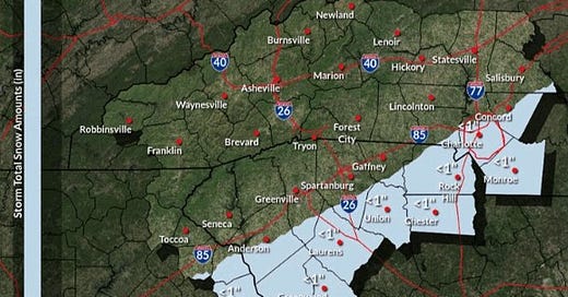
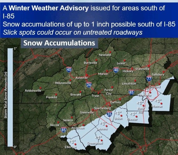
A dusting of snow in Charlotte could imperil the evening commute; National Weather Service forecasts up to 1” south of I-85
by Steve Lyttle
A historic winter storm for the Gulf Coast is now expected to bring some snow as far inland as Charlotte later Tuesday afternoon and evening. Snowfall totals will be light, but the big question is how much impact will the snow have?
A typical Charlotte winter storm includes snow and sleet, with temperatures near freezing. In those cases, roads can get ice-covered for a while, but the amount of travel trouble depends on the amount of precipitation.
Today’s system is different: The snow that falls this afternoon and evening will hit roads that are colder than they normally are during winter storms. That means roads could get snow-covered and icy in a hurry — and right around the time of the evening commute.
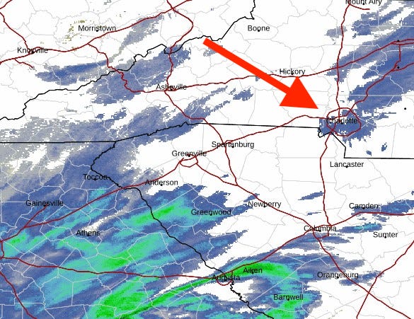
The atmosphere in the Charlotte region is very dry (as cold air often is). So initially, snowflakes will dry up before reaching the ground. Check out the National Weather Service radar shot from 10:08 a.m. today. See the blue over Charlotte? That would indicate snow is falling, but the atmosphere is very dry, and snow is evaporating as it comes down:
Radar from National Weather Service as of 10:08 a.m. on Tuesday. It seems to show that snow is falling in Charlotte, but the flakes are not reaching the ground.
Much of the snow that crosses the Charlotte area will be absorbed later today, and that’s what makes the snowfall forecast so tricky. It will take a while for the atmosphere to “moisten up,” thereby allowing snow to reach the surface.
So we’re left with these snowfall estimates for our area:
Central Charlotte: A coating to 1/2 inch.
South/southeast Mecklenburg, southern Cabarrus, western Union, Lancaster panhandle, northern York: Maybe 1/2 to 1 inch.
Southeastern Union, Lancaster, southern York: About 1 inch
North Mecklenburg, northern Cabarrus, Iredell, Gaston, Lincoln: Some snow flurries, but little or no accumulation.
The National Weather Service in Greenville-Spartanburg is forecasting up to 1” of accumulated snow south of I-85.
This forecast might be refined, as the storm system moves farther east today. Meteorologists are watching closely to see how far north snow is falling in Mississippi, Alabama and Georgia. That will be a clue about what happens here.
Slick roads: In the meantime, prepare for some slick roads after 5 or 6 p.m. tonight, especially south and southeast of central Charlotte.
Steve Lyttle is a longtime Charlotte-area weather writer with a passion for meteorology and delivering smart, insightful updates that aim to inform and educate. Follow his “Weather With Steve” Facebook page for daily updates on Charlotte weather.
Need to sign up for this e-newsletter? We offer a free version, as well as paid memberships for full access to all 4 of our local newsletters:
The Charlotte Ledger is a locally owned media company that delivers smart and essential news. We strive for fairness and accuracy and will correct all known errors. The content reflects the independent editorial judgment of The Charlotte Ledger. Any advertising, paid marketing or sponsored content will be clearly labeled.
◼️ About The Ledger • Our Team • Website
◼️ Newsletters • Podcast • Newcomer Guide • A Better You email series
◼️ Subscribe • Sponsor • Events Board • Merch Store • Manage Your Account
◼️ Follow us on Facebook, Instagram, X/Twitter, LinkedIn, Substack Notes


