Weather Extra: Heaviest downpours will be Friday
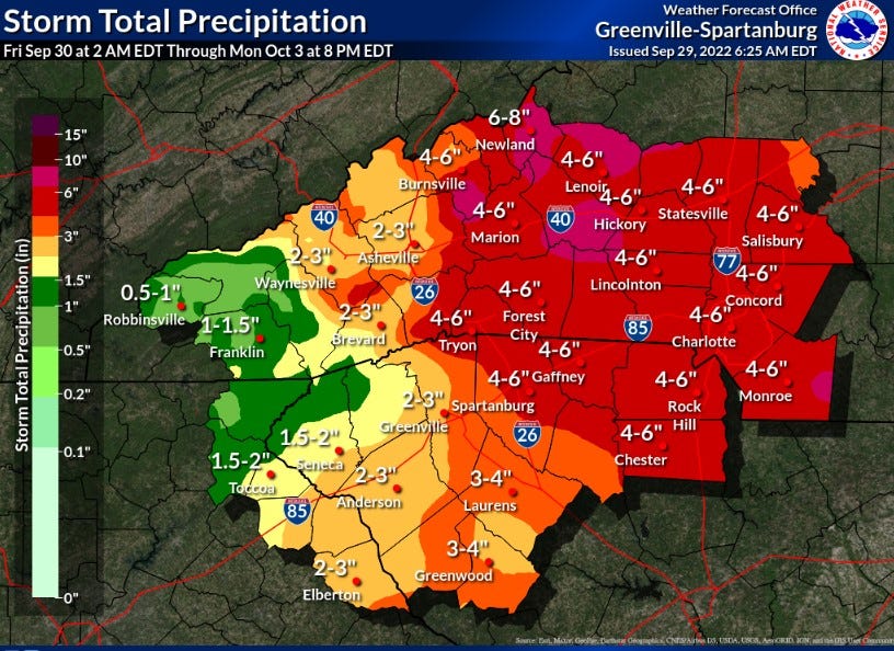
Get ready: In Charlotte, expect 4-5 inches of rain, with possible flooding in spots; Wind gusts of up to 50 mph could knock out power
You’re reading a special weather edition of The Charlotte Ledger, with solid, authoritative information to help you plan your day (or evening) ahead. Not a Ledger member? Sign up here.
Friday afternoon and evening expected to be the worst of it in the Charlotte region; Saturday looks salvageable
by Steve Lyttle
Let’s start this morning by offering a digital moment of silence for the people of Florida, especially in southwest Florida. Hurricane Ian obviously has devastated a chunk of the state, with reports of monumental property damage and at least some loss of life. Prayers for those folks.
Now, for us: What exactly are we looking at? First, the basics. Ian is now a tropical storm. It will move back into the Atlantic later today and probably strengthen a bit, reaching 70 to 75 mph top winds before making landfall again Friday on the S.C. coast.
The National Hurricane Center has been predicting landfall near Charleston, but the computer models are pushing that north. I’d bet on Georgetown or Pawleys Island. Then the storm will move northwest.
Here’s where it gets tricky. The official forecast still shows Ian moving toward Charlotte. Common sense (and some of the computer models) say the storm would pass to our east. Don’t be surprised if the track doesn’t end up being across Anson or Richmond counties.
Either way, we’ll be close enough in the Charlotte area for some trouble. A Tropical Storm Watch is posted for much of South Carolina, including Lancaster County, at the edge of Ballantyne.
Don’t be surprised to see that changed to a warning, and then extended into some North Carolina counties: Anson, Richmond and Union are good candidates, but Mecklenburg and even Cabarrus are possibilities. One other note: With the increased speed of the system, we’re likely to salvage some of Saturday. It isn’t the total washout we once thought, especially in the afternoon and evening.
As of 10 a.m. Thursday, here are some forecasts for this system:
◼️ TODAY’S WEATHER: Cloudy and breezy, with gusts up to 30 mph. But no rain. And it will be chilly (upper 60s). This is a day to put away anything on your property that could be blown about. It also wouldn’t hurt to make sure you're ready for power outages.
◼️ WHEN DOES IT ARRIVE? Some rain could be falling at daybreak Friday. Winds will pick up and rainfall will increase around midday.
◼️ WHEN'S THE WORST? It’s likely to be from early Friday afternoon until around daybreak Saturday.


◼️ HOW MUCH RAIN? Right now, the forecast is for 4-5 inches in the immediate Charlotte area. Totals will be higher to the east (Union, Anson, Richmond) and southeast (Lancaster, Chesterfield) and lower to the west of Charlotte.
◼️ HOW MUCH WIND? This depends on the track. If it follows the National Hurricane Center track, we’re talking about sustained winds of 25-30 mph, with gusts to 50 mph.
◼️ POWER OUTAGES? Wind gusts over 40 or 45 mph usually result in more than just isolated power outages. So be prepared to lose power. My circuit is especially prone to this (we’ve lost power eight times in 2 1/2 years). I’m getting a Plan B and C ready.
◼️ FLASH FLOODING? This is certainly possible, even though we haven't had precipitation here in more than two weeks. If it comes down hard enough and fast enough, we’ll have flooding. The Charlotte Observer this week quoted a Storm Water Services spokesman requesting people clear the storm drains in their neighborhoods before the storm hits.
◼️ WHAT COULD CHANGE? What I’m watching closely is the track of Ian, once it moves inland in South Carolina. The farther to our east it passes, the less rainfall and wind we get. That remains to be seen. But the computer model trend Thursday morning has been nudging the path east.
Steve Lyttle is a longtime Charlotte-area weather writer with a passion for meteorology and delivering smart, insightful updates that aim to inform and educate. Follow his “Weather With Steve” Facebook page for daily updates on Charlotte weather.
How to get ready
Mecklenburg County Emergency Management recommends:
Secure all items and valuables you have outside
Have an emergency kit
Have a family communications plan
Stock up on food and water
Gather flashlights and batteries
Charge devices
Sign up for emergency alerts at charmeckalerts.org
◼️ Preparation tips from Duke Energy
Need to sign up for this e-newsletter? We offer a free version, as well as paid memberships for full access to all 4 of our local newsletters:
➡️ Opt in or out of different newsletters on your “My Account” page.
➡️ Learn more about The Charlotte Ledger
The Charlotte Ledger is a locally owned media company that delivers smart and essential news through e-newsletters and on a website. We strive for fairness and accuracy and will correct all known errors. The content reflects the independent editorial judgment of The Charlotte Ledger. Any advertising, paid marketing, or sponsored content will be clearly labeled.
Like what we are doing? Feel free to forward this along and to tell a friend.
Social media: On Facebook, Instagram, Twitter and LinkedIn.
Sponsorship information: email brie@cltledger.com.
Executive editor: Tony Mecia; Managing editor: Cristina Bolling; Staff writer: Lindsey Banks; Contributing editor: Tim Whitmire, CXN Advisory; Contributing photographer/videographer: Kevin Young, The 5 and 2 Project


