Weather Extra: Prepare for possible flooding as Debby arrives Thursday
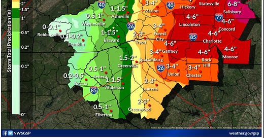
Showers should begin overnight and will last throughout the day Thursday, weakening by evening. Area could see 4-6 inches of rain, which is likely to cause flooding.
You’re reading a special weather edition of The Charlotte Ledger, with solid, authoritative information to help you plan your day (or evening) ahead. Not a Ledger member? Sign up here.
Heaviest Debby rains and possible flooding expected in Charlotte Thursday morning and afternoon, with 4-6 inches anticipated; here’s a list of roads that tend to flood
by Steve Lyttle
Tropical Storm Debby was swirling off the coast of Charleston and preparing for a second landfall at midday today before an expected move northward through the Pee Dee region of South Carolina and the eastern sandhills of North Carolina.
In the Charlotte region, we’ll see bands of showers and maybe a few thunderstorms begin around midnight or maybe a bit later. Feeder bands in the storm will continue circulating into the Piedmont throughout the day on Thursday and are expected to weaken by Thursday evening. Some showers will be left over on Friday morning, but conditions should improve rapidly as the storm moves north.
It’s tough to predict who’ll get hit hard, and when.
Flooding risk: It seems likely, at this point, that parts of the Piedmont, including the Charlotte region, will get hit hard.
The official forecast is 4-6 inches of rain for Charlotte. That much rain in a 24-hour period, with some of it falling at a rate of 2 inches per hour, will cause flooding. Heavier amounts are forecast to our east, and the flood threat will be worse there.
Winds won’t be terribly strong, gusting to 25-30 mph at times. But those winds could be enough to knock down some trees, with root systems weakened by the heavy rain.
A Flood Watch is in effect from late Wednesday through Friday morning. That watch area has been expanded, adding Gaston, Lincoln, Iredell, Catawba and Caldwell counties. Earlier counties in the watch area included Mecklenburg, Cabarrus, Union, Anson, Richmond, Stanly and Montgomery in North Carolina — plus Chesterfield, Lancaster, York and Chester in South Carolina.
The Weather Prediction Center has Charlotte in a Moderate risk of flash flooding, saying there is a 40% chance of a flash flood within 10 miles of any given point. A high risk, with a 70% chance of flash flooding within 10 miles, is in effect just to our east. High risk is a Level 4 (of 4) levels. Moderate is Level 3.
Remember: today’s the day to clean out those gutters and prep your basement for flooding.
Roads at risk for flooding
Flash flooding is expected in places around the Charlotte region Thursday. According to National Weather Service data and other records, here are some of the flood-prone streets and intersections in Mecklenburg County. (Remember — don’t try driving through flooded roads.)
Addison Drive (southeast Charlotte, off Randolph Road)
Bud Henderson Road (Huntersville)
Caldwell and 5th Street (uptown)
Central Avenue (near Briar Creek)
Freedom Drive (at Camp Greene Street and at West Morehead)
Gilead Road (Huntersville)
Gum Branch Road (at Gum Branch Creek, in northwest Charlotte)
Independence Freeway (near Briar Creek)
I-85 near Graham street and near Little Rock Road
John Price Road (at Steele Creek in Pineville)
Lincrest Place (near Briar Creek, southeast Charlotte)
McIlwaine Road (near McDowell Creek, Huntersville)
Pavilion Boulevard (northeast Charlotte, near PNC Music Pavilion)
Polk Street (northwest Charlotte’s Greenville community)
Providence Road (near Colonial Avenue)
Sam Newell Road (just south of Independence Boulevard, Matthews)
Shamrock Drive (near Eastway Drive)
Shannonhouse Drive (at Briar Creek, northeast Charlotte)
Southwest Boulevard (at Stewart Creek, west Charlotte)
West Boulevard (low area near I-77)
Wilkinson Boulevard (at Ashley Road)
Steve Lyttle is a longtime Charlotte-area weather writer with a passion for meteorology and delivering smart, insightful updates that aim to inform and educate. Follow his “Weather With Steve” Facebook page for daily updates on Charlotte weather.
Need to sign up for this e-newsletter? We offer a free version, as well as paid memberships for full access to all 4 of our local newsletters:
➡️ Opt in or out of different newsletters on your “My Account” page.
➡️ Learn more about The Charlotte Ledger
The Charlotte Ledger is a locally owned media company that delivers smart and essential news through e-newsletters and on a website. We strive for fairness and accuracy and will correct all known errors. The content reflects the independent editorial judgment of The Charlotte Ledger. Any advertising, paid marketing, or sponsored content will be clearly labeled.
Like what we are doing? Feel free to forward this along and to tell a friend.
Social media: On Facebook, Instagram, Twitter and LinkedIn.
Sponsorship information: email brie@cltledger.com.
Executive editor: Tony Mecia; Managing editor: Cristina Bolling; Staff writer: Lindsey Banks; Business manager: Brie Chrisman


