Weather Extra: Slight brush with Debby today, but more coming Thursday
A few outer bands will dampen Charlotte today, but heavy rains aren't expected until Thursday; storm should taper off locally Friday
You’re reading a special weather edition of The Charlotte Ledger, with solid, authoritative information to help you plan your day (or evening) ahead. Not a Ledger member? Sign up here.
Heavy rains from Tropical Storm Debby are expected to arrive in Charlotte on Thursday, dumping 4-8 inches, with a threat of flooding
Now’s a good time to check those gutters and sump pumps
by Steve Lyttle
We’ll get a taste today of what Tropical Storm Debby has to offer, but the real impact of the storm isn’t likely to be felt in the immediate Charlotte region until Thursday and perhaps Friday.
Today’s a good day for some storm preparations:
Clean the storm drains near your house.
If you have creeks nearby, try to make sure they’re not clogged.
If you rely on a flood protection device at your home (i.e. a sump pump), make sure everything is working properly.
Need to mow? Now’s your chance.
First, for the details: The center of Debby’s circulation is near Savannah, with top sustained winds of 45 mph. But those winds aren’t the story. Feeder bands around the storm are coming inland and dumping very heavy rain along the coast from Savannah up to near Wilmington.
Those feeder bands also are carrying a few tornadoes inland. One twister hit Edisto Island late Monday night, and there have been several tornado warnings Tuesday morning in the Holden Beach/Ocean Isle Beach area. This isn’t a good week to be at the beach.
But the storm’s impacts are being felt far inland, too. The outer bands of Tropical Storm Debby are circulating just to the southeast of Mecklenburg County today. Rain is falling in Lancaster and Monroe, but the outer bands of the storm are having a tough time pushing much farther to the northwest.
A couple of main points, and then we’ll get into specifics:
Debby is forecast to move a bit offshore, eventually re-strengthen to a 60 mph tropical storm, and then move back inland Thursday in South Carolina.
The storm’s exact track isn’t important. What’s important is where the heavy rain will fall.
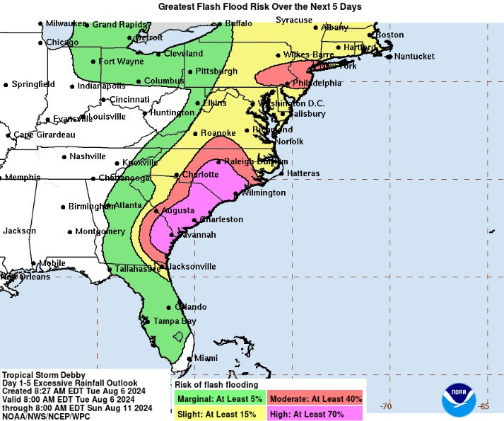
I’ve included the Weather Prediction Center map on flash flooding probabilities. That purple (“high”) risk is rather rare. It’s issued on only about 4% of days each year, and usually for small areas. The red (“moderate”) risk now includes much of the Charlotte area:
On Debby’s timing ...
Today: We’ll stay cloudy and humid, and a few outer bands from Debby will circulate far enough northward to reach Charlotte. Rainfall should be light, though.
Wednesday: We might get a break from the rain. Debby is forecast to move a bit eastward, out into the Atlantic, and the current thinking is that movement will carry the rain farther to our east. So we might just see a few scattered showers and storms in the Charlotte area.
Thursday: Debby’s heavy rains will move into the Charlotte region. This is when flooding will be a real threat, and the threat is expected to last through the night.
Friday: Debby will be moving northward, through North Carolina, so the heavy rain is likely to taper off to scattered showers and thunderstorms.
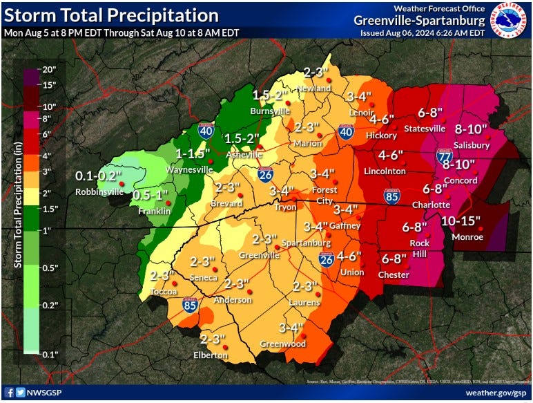
RAINFALL: As you can see from the map below, the cut-off between very heavy, heavy, moderate and light rain won’t be far from the Charlotte area. And a slight deviation in Debby’s predicted path can change everything.
But as it stands, 4-7 inches of rain looks feasible for Mecklenburg County, with the higher totals (6-8 inches) for southeast Mecklenburg, Union and Lancaster counties.
WIND: This isn’t likely to be a big issue, although gusts to 30 mph are possible Thursday and Thursday night. This becomes a bit of a problem if wind gusts knock down trees (with the trees’ root systems weakened by rain), and the trees knock down power lines.
TORNADOES: This isn’t likely to be an issue here in the Piedmont, because there won’t be a lot of wind shear (changing wind directions in the atmosphere).
What’s happening to our east: It could get bad in the N.C. Sandhills and the S.C. Pee Dee regions.
The airport in North Charleston reported 4.71 inches of rain Monday. That was a record for the date, breaking the old mark of 1.78. And we have a couple of days of heavy rain left.
Steve Lyttle is a longtime Charlotte-area weather writer with a passion for meteorology and delivering smart, insightful updates that aim to inform and educate. Follow his “Weather With Steve” Facebook page for daily updates on Charlotte weather.
Need to sign up for this e-newsletter? We offer a free version, as well as paid memberships for full access to all 4 of our local newsletters:
➡️ Opt in or out of different newsletters on your “My Account” page.
➡️ Learn more about The Charlotte Ledger
The Charlotte Ledger is a locally owned media company that delivers smart and essential news through e-newsletters and on a website. We strive for fairness and accuracy and will correct all known errors. The content reflects the independent editorial judgment of The Charlotte Ledger. Any advertising, paid marketing, or sponsored content will be clearly labeled.
Like what we are doing? Feel free to forward this along and to tell a friend.
Social media: On Facebook, Instagram, Twitter and LinkedIn.
Sponsorship information: email brie@cltledger.com.
Executive editor: Tony Mecia; Managing editor: Cristina Bolling; Staff writer: Lindsey Banks; Business manager: Brie Chrisman, BC Creative


